Tile Access Specification
Tiles can be used in any of the common web cartography libraries, such as Leaflet, OpenLayers and others.
Request Schema and Entry Point
https://tms[n].visicom.ua/2.0.0/[map]/[style]/[z]/[x]/[y].[format][?origin=sw|nw][&key]
Parameters
| Parameter | Description |
|---|---|
n | Subdomains - to speed up loading and load balancing, can take values "empty", 0, 1, 2 or 3 |
map | Dataset name. See more |
style | Display style name. Typically, basic styles exist for any dataset base See more |
z | Detail level (scale) from 0 to 19 |
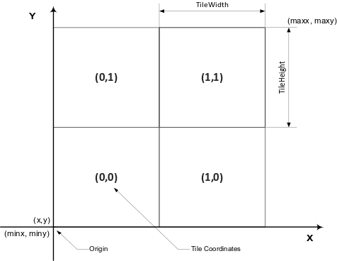
x, y | Tile number horizontally and vertically |
format | Can take one of the values png (adaptive palette), jpg, svg, pdf |
origin | Tile scheme tms or xyz nw), default is tms sw) |
lang | Desired label language, will be used where possible. One of (uk, en) or absent |
key | "Visicom Tiles" authorization key |
Tile sizes are 256 x 256 pixels.
Example
Code fragment from the Leaflet library for connecting tiles.
var map = new L.Map("map", {
    center: new L.LatLng(50.455002, 30.511284),
    zoom: 9,
    layers: [
        new L.TileLayer("https://tms{s}.visicom.ua/2.0.0/planet3/base/{z}/{x}/{y}.png", {
            attribution: "Map data © 2025 JSC "<a href='https://api.visicom.ua/'>Visicom</a>"",
            subdomains: "123",
            maxZoom: 19,
            tms: true
        })
    ]
});
Result
TMS Tile Diagram