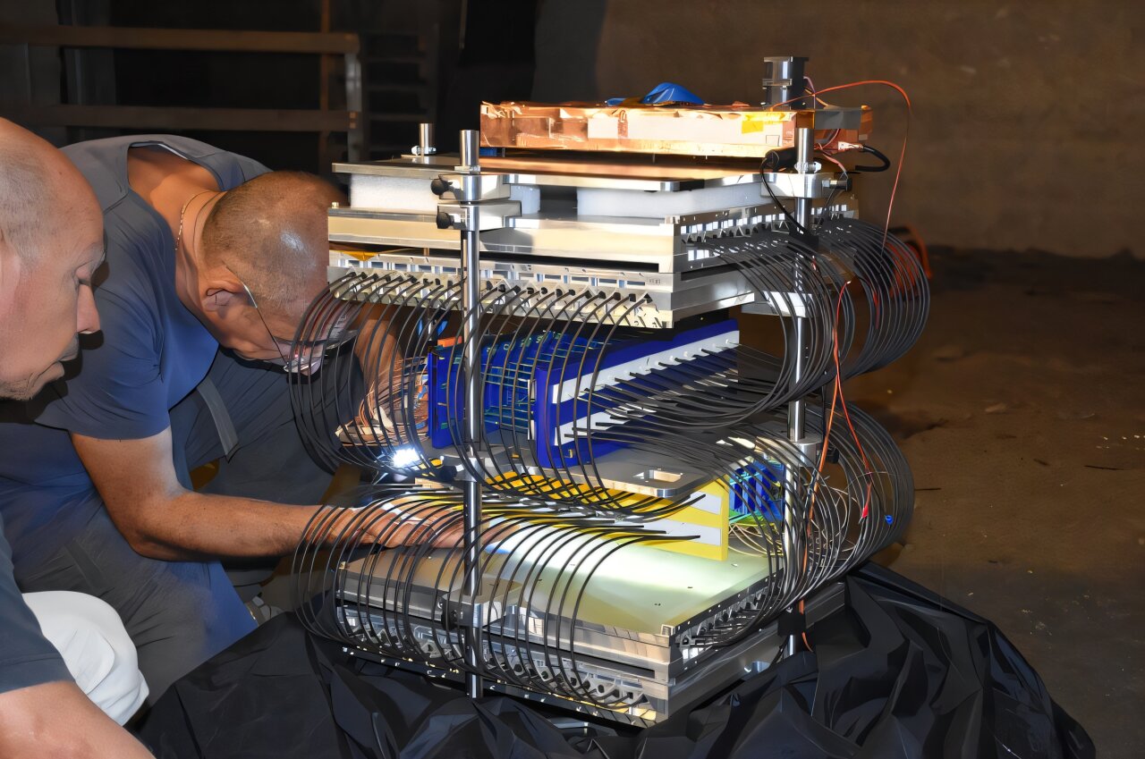
2020-10-12

Geospatial is transforming our world: the Power of Place

There are billions of sensors collecting data everywhere on Earth, and hundreds of earth observation satellites monitoring the health of the planet.

As it is said

Miniaturisation of electronics enables the production of increasingly smaller payloads for cubesats, drones and ground-based monitoring systems, reports News of cartography by Visicom with the reference on Geospatial world.

Meanwhile, cloud-based computing is providing the computational power to experiment with new business models, making geospatial data available via platforms in near real-time.

Geospatial insight is a key piece of information to enable the autonomous and connected world we are building today. It enables cars to drive down a motorway, track assets in large scale civil engineering projects, or reduce city pollution and carbon emissions via better monitoring, for example. My prediction is that within the next five years, companies of any size will make use of geospatial insights to gain a critical advantage. Working with better data will help to identify risks and opportunities faster, exploiting emerging patterns before the competition. Although, geospatial insights can unlock billions across organisations and global networks, the full economic realisation of this new paradigm is yet to occur and not guaranteed.

n #ThePowerOfPlace – A Sustainable Future with Location Insights, industry leaders and emerging thinkers discuss how cross-sector innovators can derive real-economic value from using geospatial data.

A New Data Knowledge Infrastructure

In the digital era, geospatial technologies are revolutionising the economy. From navigating public transport to monitoring supply chains and designing efficient distribution paths, location-based digital services, Earth Observation (EO) data and geospatial analytics and insights have seen an exponential growth. Machine learning and other developments in data science are facilitating much more sophisticated analysis of geospatial data than was previously possible. Some refer to this development as Geospatial 2.0.

In Geospatial 2.0, the sector is transitioning from a vertical industry to a horizontal enabler where the value of geospatial intelligence is captured across many industries.

There is now a need for establishing the knowledge-base to support geospatial innovators. Geospatial 2.0 places an emphasis on contextualising the challenges that the world is facing today. It combines location-based data and non-geographic data to provide a rich layer of information that creates value for businesses and consumers.

At the core of Geospatial 2.0 is a data and knowledge infrastructure where geo and non-geo data is acquired, transformed and delivered into the emerging geospatial data market. Here, data is published in vertically focused smart aggregators for B2B operation where new products and services are created and made available to end users via Platform-as-a-Service (PaaS) delivery model, next generation cloud-based workflow and marketplaces. Building this geospatial value chain and supporting solutions to reach technological and commercial maturity, requires a step-change not only in the way we handle data, data standards and data integration, but also in way we support a paradigm shift from business, licensing and regulatory models. A new economic model based on cross-sector cooperation and a shared geospatial data foundation needs to emerge, and it is indeed emerging.

The Collaborative Economy

To create new value in the economy, geospatial analytics must become more interdisciplinary and move from a commercially competitive model to a collaborative one. The geospatial community must utilise skills from across society, with a range of experiences – many of which will not come immediately from the GIS, space, or corporate worlds. It is only through a deep understanding of the specific needs and problems of users that technology-driven innovation can transition from R&D into the real economy. In order to tackle global challenges and capitalise on market opportunities, we must also incentivise the sharing of data and collaboration. Currently, data owners are not incentivised to de-silo data and make it available, because there is an absence of trust that they will be able to easily share the value being created with it. Building trust is crucial to breaking down data silos, and deliver new insights and shared value.

Thinking in Systems

Our planet is a system-of-systems, and yet we often take a siloed approach to planning our built environment that hampers progress towards wider economic, social and environmental goals. There is a need for greater exchange between organisations to understand the impacts of their work beyond their system boundaries, to harness synergies and mitigate trade-offs, and to work together for the larger objective of further human well-being on Earth. Let’s imagine a UK smart city, powered by technology solutions providers – smart street lights from Cambridge-based Telensa, ride-hailing technology from London-based Xooox, traffic data and analytics from Leeds-based Tracsis, and (recently UK-approved) electric scooter software provided by Sweden based JoyRide. Individually, these technology providers can all offer UK residents an improvement in quality of life on their own, but it is the integration of these activities as a holistic and interconnected suite of solutions that can create a positive impact greater than the sum of its parts.

Geospatial data provides a common thread between data sets, a framework for them to be maneged collectively, building actionable insights about the system-of-systems as a whole, shares Caroline Zimm, IIASA.

Collective Intelligence

To create new value in the economy, geospatial analytics must become more interdisciplinary. Technological advances have created a market opportunity, but we require a solution that is both qualitative and quantitative, drawing on a range of skills and experiences to unlock value. To date, the geospatial industry has suffered from a technocentric and homogeneous approach. Technology experts are crucial in developing the innovative solutions that power our shift towards Geospatial 2.0 – from R&D, to launching start-up companies which utilise new cutting edge technologies, but technology is not a magic bullet, and horizontally embedded solutions across multiple industries can easily become ‘masters of none’. The collective geospatial community must employ skills from across society, with a range of experiences – many of which will not come immediately from the GIS, space, or corporate worlds. It is only through a deep understanding of the specific needs and problems of users that technology-driven innovation can transition from R&D into the real economy.

To make the most of the Geospatial 2.0 opportunity, diverse and distributed human intelligence needs to be complemented by new machine capabilities that analyse data at unprecedented scale and speed, says Aleks Berditchevskaia, Nesta.

Public Trust

In business, the mining and monetisation of private data has increasingly been challenged by regulators, the media and the public. The Cambridge Analytica data scandal is an example of the dangers to businesses that work with data when ethics take a back seat to profits. As we move into a new decade, there is an opportunity to redefine the relationship that we have with the data economy. Areas of innovation which are crucial to our collective future are already starting to see the benefits of geospatially-derived data – including spatial finance, electric and multi-modal mobility, smart cities, climate risk analytics and pandemics response.

There is a strong risk of the public reacting against overly intrusive mapping of their lives, if they feel that spatial applications are things that are done to them, rather than for them, shares Ben Hawes, Benchmark Initiative.

Embracing the Power of Place

We are on the edge of a geospatial transformation. No longer a simple data set for use in specific applications, location data will be integrated with data from a plethora of other sources to unlock rich new insights, power better decision-making and catalyse new products and services across all industry sectors. It has the potential to add billions to our economy, boost the quality of life and wellbeing among our communities, and help protect our planet.

While many of the technological barriers have already been scaled, the future winners of the geospatial market recognise the human challenges that remain. Overcoming those will require a change in approach and behaviour. Action is needed to bring together people from different verticals and with different skill sets to ensure innovation is needs-led. Data silos must be broken down and a common geospatial framework built, in order to unlock shared value and enable collective intelligence. And we must shift from a competitive to a collaborative way of working, both among organisations but also in partnership with the general public, to build trust and incentivise sharing of data.

From tackling climate change to fighting pandemics, it is clear that Geospatial 2.0 has a central role to play in overcoming our greatest challenges as a species. Now is the time to work together to ensure that we can build a more resilient and human-centred future.

To explore the challenges and opportunities presented by geospatial intelligence, KTN and Ordnance Survey have collaborated on ‘The Power of Place – A Sustainable Future with Geospatial Insights’, a thought leadership publication, and associated webinar series, that explores the changing landscape of location intelligence and what it means for business as usual.